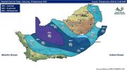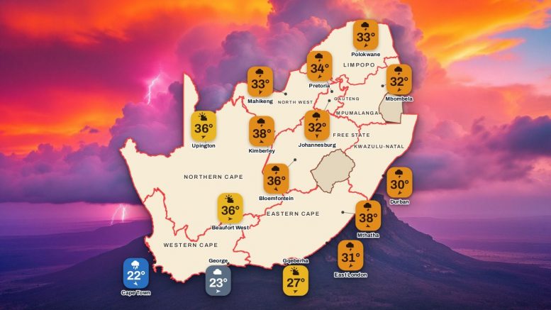

A Yellow Level 4 warning for severe thunderstorms covers Gauteng, the Mpumalanga Highveld, central-southern Limpopo, the eastern Free State and North West and most of KwaZulu-Natal, with flooding, small hail and power disruptions possible. Storms are expected around Rustenburg, Hartebeespoort, Frankfort and Reitz from 13:00 to 23:59. Musina, Kimberley and Mthatha are the hottest at 38°C, while Level 10 veld fire conditions grip the Eastern Cape interior from 08:00 to 17:59.
Weather warnings for Thursday 5 November
SAWS has 2 weather warnings in force for Thursday, the highest warning level 10 for veld fire conditions. Tap a warning to see the areas and what to do.
Red level 10
Veld Fire Conditions
Where
Molteno, Queenstown, Grahamstown, Lady Frere + 72 more
When
Thu 08:00 to 17:59
Veld Fire Conditions
Molteno, Queenstown, Grahamstown, Lady Frere + 72 more
Thu 08:00 to 17:59
Areas: Molteno, Queenstown, Grahamstown, Lady Frere, Somerset East, Tarkastad, Adelaide, Fort, Jamesto, Jansenville, Barkly East, Cofimvaba, Graaff – Reinet, Burgersdorp, Ngcobo, Port Alfred, Cradock, Postmasburg, De Aar, Schweizer-Reneke, Griquastad, Hoopstad, Bothaville, Aliwal North, Groblershoop, Prieska, Ladybrand, Kathu, Augrabies Falls, Warrenton and 46 more.
- Damage to property/settlements, loss of grazing land and possible loss of animal and/or human life.
What to do: Public is advised not to start any fires under these conditions.
At first sign of smoke, every possible measure should be taken in order to bring the fire under control in the shortest possible time.
Yellow level 4
Severe Thunderstorms
Where
Rustenburg, Frankfort, Hartebeespoort, Reitz
When
Thu 13:00 to 23:59
Severe Thunderstorms
Rustenburg, Frankfort, Hartebeespoort, Reitz
Thu 13:00 to 23:59
Areas: Rustenburg, Frankfort, Hartebeespoort, Reitz.
- Flooding of roads, settlements and low-lying areas.
- Structural damages to settlements due to strong winds
- Disruption to municipal and other essential services.
What to do: Drive safely and reduce speed were necessary. Do not attempt to cross flooded roads. Do not seek shelter under trees or tall objects during storms. Keep an eye on the SAWS website for any updates regarding flooding development.
SAWS advisory
Impact-Based Warnings
What
3 items, tap to read
Impact-Based Warnings
3 items, tap to read
- Yellow Level 4 Warning: Severe Thunderstorms resulting in flooding and damage of settlements/property, and localised disruptions to power supply and communications due to wind and large amount of small hail over Gauteng, Mpumalanga Highveld, central-southern parts of Limpopo, eastern parts of both the Free State and North West as well as KwaZulu-Natal, except in the extreme north-east.
- Yellow Level 2 Warning: Severe Thunderstorms resulting in localised flooding and damage of settlements/property, and localised disruptions to power supply and communications due to wind and hail over southern Limpopo, escarpment of Mpumalanga, the central and western parts of both North West and Free State as well as the northern interior of Eastern Cape.
- Yellow Level 1 Warning: Damaging Interior Winds resulting in localised damage to settlements, transport routes and travel services affected by winds, localised problems for high-sided vehicles on prone routes over eastern parts of Northern Cape as well as the northern interior of Eastern Cape.
SAWS advisory
Fire Danger Warnings
What
1 item, tap to read
Fire Danger Warnings
1 item, tap to read
- Extremely high fire danger conditions are expected over Northern Cape, except along the coast and adjacent interior, most parts in the east of Western Cape, the interior of Eastern Cape and in places south of the escarpment, western Free State, as well as in places in North West, Gauteng, Limpopo and Mpumalanga.
SAWS advisory
Advisories
What
1 item, tap to read
Advisories
1 item, tap to read
- Hot and humid weather will result in extremely uncomfortable conditions over the eastern parts of KwaZulu-Natal.
Moon tonight
Waning Crescent
13% lit
The moon tonight is a waning crescent, about 13% lit, and the next new moon is on Monday 9 November.
ADVERTISEMENT
Weather today by province, Thursday 5 November
View Weather Forecast for TomorrowView the weather tomorrow on the 7-Day Weather Forecast
Each province lists its main towns with today’s sky, low and high, rain chance and wind; every province starts closed, tap one to open it. Tide times are inside Western Cape, Northern Cape, Eastern Cape and KwaZulu-Natal. Today Johannesburg peaks at 32°C.
Gauteng
Johannesburg, Pretoria, Soweto, Vereeniging
A Yellow Level 4 storm warning brings a risk of hail and flooding, with a 60% chance of thundershowers. Pretoria and Soweto reach 34°C, Vereeniging 33°C and Johannesburg 32°C after a low of 17°C.
Johannesburg today
Rain, storms32°17°60%N 10 km/h
Tap for cities and townsTap to close Gauteng
Tap for cities and townsTap to close Gauteng
Towns today
| Town | Weather | Lo | Hi | Rain | Wind km/h |
|---|---|---|---|---|---|
| Johannesburg | Rain, storms | 17° | 32° | 60% | N 10 |
| Pretoria | Rain, storms | 18° | 34° | 60% | NE 10 |
| Soweto | Rain, storms | 17° | 34° | 60% | N 10 |
| Vereeniging | Rain, storms | 17° | 33° | 60% | NW 15 |
Western Cape
Cape Town, Stellenbosch, Paarl, George · tides
Cape Town sees showers between 17°C and 22°C, with Stellenbosch and Paarl at 25°C and a 30% chance of rain. George is cloudy and dry at 23°C, and fire danger is extremely high in the east.
Cape Town today
Rain showers22°17°30%NW 15 km/h
Tap for cities and townsTap to close Western Cape
Tap for cities and townsTap to close Western Cape
Towns today
| Town | Weather | Lo | Hi | Rain | Wind km/h |
|---|---|---|---|---|---|
| Cape Town | Rain showers | 17° | 22° | 30% | NW 15 |
| Stellenbosch | Rain showers | 12° | 25° | 30% | WNW 15 |
| Paarl | Rain showers | 16° | 25° | 30% | WNW 15 |
| George | Cloudy | 15° | 23° | 0% | W 10 |
Tides: Cape Town
| Day | Low tide | High tide |
|---|---|---|
| Thu 5 Nov | 06:42, 19:19 | 00:41, 12:52 |
Mpumalanga and Limpopo next today: Mbombela reaches 32°C and Polokwane reaches 33°C.
Mpumalanga
Mbombela, eMalahleni, Ermelo
Level 4 storms are possible over the Highveld and Level 2 storms along the escarpment, with a 60% chance of rain. Mbombela peaks at 32°C, eMalahleni 31°C and Ermelo 30°C after a cool 13°C start.
Mbombela today
Rain, storms32°16°60%NE 10 km/h
Tap for cities and townsTap to close Mpumalanga
Tap for cities and townsTap to close Mpumalanga
Towns today
| Town | Weather | Lo | Hi | Rain | Wind km/h |
|---|---|---|---|---|---|
| Mbombela | Rain, storms | 16° | 32° | 60% | NE 10 |
| eMalahleni | Rain, storms | 15° | 31° | 60% | NW 15 |
| Ermelo | Rain, storms | 13° | 30° | 60% | WNW 10 |
Limpopo
Polokwane, Tzaneen, Thohoyandou, Musina
Musina is the hottest at 38°C, with Tzaneen and Thohoyandou at 36°C under partly cloudy skies. Polokwane reaches 33°C with a 30% chance of thundershowers, and the central and southern parts carry a Level 4 storm warning.
Polokwane today
Rain, storms33°19°30%NE 10 km/h
Tap for cities and townsTap to close Limpopo
Tap for cities and townsTap to close Limpopo
Towns today
| Town | Weather | Lo | Hi | Rain | Wind km/h |
|---|---|---|---|---|---|
| Polokwane | Rain, storms | 19° | 33° | 30% | NE 10 |
| Tzaneen | Partly cloudy | 20° | 36° | 0% | E 5 |
| Thohoyandou | Partly cloudy | 22° | 36° | 0% | ESE 5 |
| Musina | Partly cloudy | 22° | 38° | 0% | E 10 |
North West and Free State follow today: Mahikeng reaches 33°C and Bloemfontein reaches 36°C.
North West
Mahikeng, Rustenburg, Potchefstroom, Klerksdorp
Severe thunderstorms are expected around Rustenburg from 13:00 to 23:59, with a 60% chance of rain across the province. Rustenburg reaches 36°C, Potchefstroom and Klerksdorp 35°C and Mahikeng 33°C.
Mahikeng today
Rain, storms33°19°60%NNE 15 km/h
Tap for cities and townsTap to close North West
Tap for cities and townsTap to close North West
Towns today
| Town | Weather | Lo | Hi | Rain | Wind km/h |
|---|---|---|---|---|---|
| Mahikeng | Rain, storms | 19° | 33° | 60% | NNE 15 |
| Rustenburg | Rain, storms | 20° | 36° | 60% | NNW 10 |
| Potchefstroom | Rain, storms | 17° | 35° | 60% | N 20 |
| Klerksdorp | Rain, storms | 17° | 35° | 60% | N 15 |
Free State
Bloemfontein, Bethlehem, Kroonstad
Frankfort and Reitz face severe thunderstorms from 13:00 until 23:59. Bloemfontein climbs to 36°C with a 30% chance of showers, Kroonstad reaches 35°C and Bethlehem 30°C, both with a 60% chance of rain.
Bloemfontein today
Rain, storms36°15°30%NW 20 km/h
Tap for cities and townsTap to close Free State
Tap for cities and townsTap to close Free State
Towns today
| Town | Weather | Lo | Hi | Rain | Wind km/h |
|---|---|---|---|---|---|
| Bloemfontein | Rain, storms | 15° | 36° | 30% | NW 20 |
| Bethlehem | Rain, storms | 15° | 30° | 60% | NW 15 |
| Kroonstad | Rain, storms | 17° | 35° | 60% | NW 15 |
Northern Cape, Eastern Cape and KwaZulu-Natal close the list today: Kimberley reaches 38°C, Gqeberha reaches 27°C and Durban reaches 30°C.
Northern Cape
Kimberley, Upington, Springbok, De Aar · tides
Kimberley hits 38°C with a 30% chance of thundershowers, and De Aar reaches 34°C. Upington stays dry at 36°C, Springbok is cloudy at 24°C, and fire danger is extremely high inland.
Kimberley today
Rain, storms38°18°30%WNW 25 km/h
Tap for cities and townsTap to close Northern Cape
Tap for cities and townsTap to close Northern Cape
Towns today
| Town | Weather | Lo | Hi | Rain | Wind km/h |
|---|---|---|---|---|---|
| Kimberley | Rain, storms | 18° | 38° | 30% | WNW 25 |
| Upington | Partly cloudy | 17° | 36° | 0% | WSW 20 |
| Springbok | Cloudy | 16° | 24° | 0% | W 20 |
| De Aar | Rain, storms | 17° | 34° | 30% | WNW 30 |
Tides: Port Nolloth (modelled)
| Day | Low tide | High tide |
|---|---|---|
| Thu 5 Nov | 06:00, 18:34 | 12:12 |
Eastern Cape
Gqeberha, East London, Mthatha, Queenstown · tides
Level 10 veld fire conditions hit Queenstown, Molteno, Lady Frere, Tarkastad, Somerset East and Grahamstown from 08:00 to 17:59. Mthatha reaches 38°C and Queenstown 37°C under a Level 2 storm warning, while Gqeberha stays dry at 27°C.
Gqeberha today
Partly cloudy27°18°0%WSW 30 km/h
Tap for cities and townsTap to close Eastern Cape
Tap for cities and townsTap to close Eastern Cape
Towns today
| Town | Weather | Lo | Hi | Rain | Wind km/h |
|---|---|---|---|---|---|
| Gqeberha | Partly cloudy | 18° | 27° | 0% | WSW 30 |
| East London | Thunderstorms | 18° | 31° | 60% | NE 15 |
| Mthatha | Thunderstorms | 16° | 38° | 60% | WNW 10 |
| Queenstown | Thunderstorms | 14° | 37° | 60% | WNW 20 |
Tides: Gqeberha
| Day | Low tide | High tide |
|---|---|---|
| Thu 5 Nov | 07:03, 19:44 | 00:57, 13:15 |
Tides: East London
| Day | Low tide | High tide |
|---|---|---|
| Thu 5 Nov | 07:06, 19:47 | 01:05, 13:23 |
KwaZulu-Natal
Durban, Pietermaritzburg, Richards Bay, Newcastle · tides
A Level 4 storm warning covers most areas except the far north-east, with a 60% chance of thundershowers. Pietermaritzburg and Richards Bay reach 36°C, Newcastle 34°C, and Durban is hot and humid at 30°C.
Durban today
Rain, storms30°21°60%NE 25 km/h
Tap for cities and townsTap to close KwaZulu-Natal
Tap for cities and townsTap to close KwaZulu-Natal
Towns today
| Town | Weather | Lo | Hi | Rain | Wind km/h |
|---|---|---|---|---|---|
| Durban | Rain, storms | 21° | 30° | 60% | NE 25 |
| Pietermaritzburg | Rain, storms | 18° | 36° | 60% | NNW 10 |
| Richards Bay | Rain, storms | 21° | 36° | 30% | NNE 10 |
| Newcastle | Rain, storms | 17° | 34° | 60% | WNW 10 |
Tides: Durban
| Day | Low tide | High tide |
|---|---|---|
| Thu 5 Nov | 07:08, 19:45 | 01:06, 13:27 |
View Weather Forecast for TomorrowView the weather tomorrow on the 7-Day Weather Forecast
ADVERTISEMENT
Forecast data: the South African Weather Service and other third-party sources and providers, brought together with the latest AI tools. We take great care to get every figure right, but mistakes are possible.